|
|
|
Lower Saxony
Sun. 11th Aug., 2002
|
 |
|
Hanover Street is named after the Royal House
of that name. The German George I became ruler in 1714 after the death of Queen Anne, the last of the Stuarts.
Parliament passed the "Act of Settlement" in 1701 to not only allow this, but also decreeing that no Catholic should ever be ruler, and no foreigner should occupy a Government post.
The last Hanoverian was William IV who opposed votes for the people, but was forced to accept Earl Grey's Reform Bill of 1832. The monument to this step towards enfranchisement stands today at the heart of Graingertown. In 1837 Victoria came to the throne and was forbidden by Hanoverian law to rule the two countries and she remained in Britain, taking the name of Saxe-Coburg-Gotha.
|
|
 |
|
The steep hill runs up from the riverside at the junction of Close and Forth Banks to Westgate Road near the Castle.
This eastward view shows the smooth stones set in the road to allow the horses pulling carts up the hill an easier job. The wheels
found less resistance than on the uneven cobbles.
The buildings along the right of this street were bonded warehouses. These were special repositories for materials and products on which Excise
Duty was payable, but exempt for their stay in the warehouse. The principal wares stored were alcoholic spirits and tobacco products during their export import cycle.
The warehouses were numbered
10, 20, 30, 40, and 50 from the top to the foot of the hill. Only 40 remains following demolition and fires.
|
|
|
|
|
|
These warehouses were built between 1841 and 1844 by Amor Spoor who carried out his wealthy trade until his
death and it continued on beyond the centenary of these buildings. The warehouses were finally abandoned during the late 1970s and a forlorn "For Sale" notice has flapped for almost a generation on the
lower range abutting Close at riverside level.
Houses 10 to 30 were demolished during the early 1980s and replaced with a terraced garden with pleasant walkways and steps down to the new Riverside
development, spearheaded by the City council and designed by Terry Farrell.
The new plans included a large hotel with massive enclosed car park, a prestige office development, now the home of
British Telecom since their move from the purpose built Swan House, a riverside promenade, and the conversion of some mediæval buildings into a restaurant and bar.
Warehouse 50 was severely fire
damaged in the early 1990s and its carcass was beyond repair and demolished.
The future of the remaining warehouse must be in doubt as the surrounding development makes it an eyesore. I suspect
that the conversion costs, say to city apartments, would be prohibitive and uneconomic.
Maybe some brave soul will find a commercial use for the building, other famous warehouses have been
converted to housing and in one case a science museum.
|
|
|
This view from the site of Warehouse 50 shows the Queen Elizabeth II bridge opened in 1980 to carry the Metro
Light Transit trains over the river. It was designed and built by A. Fairhurst & Partners. From the ground the bridge is unremarkable, but Metro passengers emerge from a subterranean tunnel onto a
high and spectacular view of the riverside, before being thrust back into the tunnel.
The King Edward VII rail bridge lies beyond. It was opened in 1906, was designed by Charles Harrison, nephew
of the main engineer of the High Level Bridge, and was built by the Cleveland Bridge and Engineering Co.
The new Redheugh bridge is just visible beyond that.
|
|
|
The eastern warehouses, numbers 10 to 30 were within the Town Walls and it was this boundary that suggested the
earlier demolition and the council's construction of the terraced gardens.
Here, above Hanover Street, on the site of the old Whitefriars monastery, is the wall. This section stretches from the
railway lines that cut through the Castle during the mid 19th century, to Hanover Street. From here the wall continued down the steep bank to the river. A set of steps were built into the wall and
accurately called "Breakneck Stairs". Hanover Stairs were more friendly and lay to the east and passed through a tunnel in the warehouse complex.
|
|
|
 |
|
|
|
The Town Wall was partially demolished at this point of Hanover street during the 1770s and some stones were later
incorporated into this side wall.
Seen from Close below the line of the old wall is visible. This was entirely covered by the warehouses.
Close, the street at the bottom the picture, is so
called because of the closed in aspect of this thoroughfare, with tall warehouses on both sides, and loading winches swinging packages aloft. Some people incorrectly call it "The Close", but it never had
the definite article in the name.
|
|
|
This view looking west along Close shows the remaining Warehouse 40 and the wall remnants and Breakneck Stairs.
That white sided building marks the junction with Forth Banks running right and Skinner Burn Road straight ahead.
The massive Copthorne Hotel lies to the left and forms a sort of comfy
warehouse for people.
|
|
|
|
|
|
The remaining warehouse can evoke the busy Victorian time of it heyday.
The only visitors today are the
birds who make it their home. Those massive wooden identity numbers were originally painted bright green
|
|
|
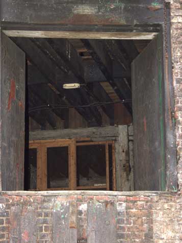
A peek inside the open hatches reveals some of the internal structure. Some of the offices and the position of the
light fitting shows that the beams were always exposed.
This may be the last glimpse of a Tyneside landmark. It is not in the same league as the Baltic or Co-op building now resplendent in their
new use.
The view below, from the top of Hanover Stairs, shows the new office development home to British Telecom. Cranes in Gateshead show the site of the Half Moon Lane development.
Hanover Street may once again ring with commercial activity, but I fear not with the existing building. Is this blackened hulk worth saving? No delay was considered when just metres away a new casino
replaced old warehouses.
|
|
|
|
|
|
|
|
Site and contents (unless otherwise stated) ©
Tim. Pickford-Jones and Timmonet, Newcastle upon Tyne, United Kingdom.
|
|
|
|
|
|
|
|
 |
|
|
If you should arrive here via a search, or be missing the navigation on the left hand side, click this button.
|
|
|